Geography
Scope
London, also referred to as Greater London, is one of nine regions of England and the top-level subdivision covering most of the city's metropolis.note The small ancient City of London at its core once comprised the whole settlement, but as its urban area grew, the Corporation of London resisted attempts to amalgamate the city with its suburbs, causing "London" to be defined in a number of ways for different purposes.
Forty per cent of Greater London is covered by the London post town, within which 'LONDON' forms part of postal addresses. The London telephone area code (020) covers a larger area, similar in size to Greater London, although some outer districts are excluded and some places just outside are included. The Greater London boundary has been aligned to the M25 motorway in places.
Outward urban expansion is now prevented by the Metropolitan Green Belt, although the built-up area extends beyond the boundary in places, resulting in a separately defined Greater London Urban Area. Beyond this is the vast London commuter belt. Greater London is split for some purposes into Inner London and Outer London. The city is split by the River Thames into North and South, with an informal central London area in its interior. The coordinates of the nominal centre of London, traditionally considered to be the original Eleanor Cross at Charing Cross near the junction of Trafalgar Square and Whitehall, are about 51°30′26″N 00°07′39″W / 51.50722°N 0.12750°W. However the geographical centre of London, on one definition, is in the London Borough of Lambeth, just 0.1 miles to the northeast of Lambeth North tube station.
Status
Within London, both the City of London and the City of Westminster have city status and both the City of London and the remainder of Greater London are counties for the purposes of lieutenancies. The area of Greater London includes areas that are part of the historic counties of Middlesex, Kent, Surrey, Essex and Hertfordshire. London's status as the capital of England, and later the United Kingdom, has never been granted or confirmed officially—by statute or in written form.note
Its position was formed through constitutional convention, making its status as de facto capital a part of the UK's uncodified constitution. The capital of England was moved to London from Winchester as the Palace of Westminster developed in the 12th and 13th centuries to become the permanent location of the royal court, and thus the political capital of the nation. More recently, Greater London has been defined as a region of England and in this context is known as London.
Topography
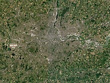
Greater London encompasses a total area of 1,583 square kilometres (611 sq mi), an area which had a population of 7,172,036 in 2001 and a population density of 4,542 inhabitants per square kilometre (11,760/sq mi). The extended area known as the London Metropolitan Region or the London Metropolitan Agglomeration, comprises a total area of 8,382 square kilometres (3,236 sq mi) has a population of 13,709,000 and a population density of 1,510 inhabitants per square kilometre (3,900/sq mi). Modern London stands on the Thames, its primary geographical feature, a navigable river which crosses the city from the south-west to the east. The Thames Valley is a floodplain surrounded by gently rolling hills including Parliament Hill, Addington Hills, and Primrose Hill. Historically London grew up at the lowest bridging point on the Thames. The Thames was once a much broader, shallower river with extensive marshlands; at high tide, its shores reached five times their present width.
Since the Victorian era the Thames has been extensively embanked, and many of its London tributaries now flow underground. The Thames is a tidal river, and London is vulnerable to flooding. The threat has increased over time because of a slow but continuous rise in high water level by the slow 'tilting' of the British Isles (up in Scotland and Northern Ireland and down in southern parts of England, Wales and Ireland) caused by post-glacial rebound.
In 1974 a decade of work began on the construction of the Thames Barrier across the Thames at Woolwich to deal with this threat. While the barrier is expected to function as designed until roughly 2070, concepts for its future enlargement or redesign are already being discussed.
Climate
| London, United Kingdom | ||||||||||||||||||||||||||||||||||||||||||||||||||||||||||||
|---|---|---|---|---|---|---|---|---|---|---|---|---|---|---|---|---|---|---|---|---|---|---|---|---|---|---|---|---|---|---|---|---|---|---|---|---|---|---|---|---|---|---|---|---|---|---|---|---|---|---|---|---|---|---|---|---|---|---|---|---|
| Climate chart (explanation) | ||||||||||||||||||||||||||||||||||||||||||||||||||||||||||||
| ||||||||||||||||||||||||||||||||||||||||||||||||||||||||||||
| ||||||||||||||||||||||||||||||||||||||||||||||||||||||||||||
London has a temperate oceanic climate (Köppen: Cfb ). Rainfall records have been kept in the city since at least 1697, when records began at Kew. At Kew, the most rainfall in one month is 7.4 inches (189 mm) in November 1755 and the least is 0 inches (0 mm) in both December 1788 and July 1800. Mile End also had 0 inches (0 mm) in April 1893. The wettest year on record is 1903, with a total fall of 38.1 inches (969 mm) and the driest is 1921, with a total fall of 12.1 inches (308 mm). The average annual precipitation amounts to about 600 mm, a value inferior to cities such as Rome, Lisbon, New York City and Sydney. Nevertheless, despite its relatively low annual precipitation, London still receives a good amount of rainy days annually – 109.6 days on the 1.0 mm threshold – Higher than, or at least akin to, the aforementioned cities.
Temperature extremes in London range from 38.1 °C (100.6 °F) at Kew during August 2003 down to −21.1 °C (−6.0 °F). However, an unofficial reading of −24 °C (−11 °F) was reported on 3 January 1740. Conversely, the highest unofficial temperature ever known to be recorded in the United Kingdom occurred in London in the 1808 heat wave. The temperature was recorded at 105 °F (40.6 °C) on 13 July. It is thought that this temperature, if accurate, is one of the highest temperatures of the millennium in the United Kingdom. It is thought that only days in 1513 and 1707 could have beaten this. Since records began in London (first at Greenwich in 1841), the warmest month on record is July 1868, with a mean temperature of 22.5 °C (72.5 °F) at Greenwich whereas the coldest month is December 2010, with a mean temperature of −6.7 °C (19.9 °F) at Northolt. Records for atmospheric pressure have been kept at London since 1692. The highest pressure ever reported is 1,050 millibars (31 inHg) on 20 January 2020, and the lowest is 945.8 millibars (27.93 inHg) on 25 December 1821.
Summers are generally warm, sometimes hot. London's average July high is 24 °C (74 °F). On average each year, London experiences 31 days above 25 °C (77.0 °F) and 4.2 days above 30.0 °C (86.0 °F) every year. During the 2003 European heat wave there were 14 consecutive days above 30 °C (86.0 °F) and 2 consecutive days when temperatures reached 38 °C (100 °F), leading to hundreds of heat-related deaths. There was also a previous spell of 15 consecutive days above 32.2 °C (90.0 °F) in 1976 which also caused many heat related deaths. The previous record high was 38 °C (100 °F) in August 1911 at the Greenwich station. Droughts can also, occasionally, be a problem, especially in summer. Most recently in Summer 2018 and with much drier than average conditions prevailing from May to December. However, the most consecutive days without rain was 73 days in the spring of 1893.
Winters are generally cool with little temperature variation. Heavy snow is rare but snow usually happens at least once each winter. Spring and autumn can be pleasant. As a large city, London has a considerable urban heat island effect, making the centre of London at times 5 °C (9 °F) warmer than the suburbs and outskirts. This can be seen below when comparing London Heathrow, 15 miles (24 km) west of London, with the London Weather Centre.
Districts
London's vast urban area is often described using a set of district names, such as Mayfair, Southwark, Wembley and Whitechapel. These are either informal designations, reflect the names of villages that have been absorbed by sprawl, or are superseded administrative units such as parishes or former boroughs.
Such names have remained in use through tradition, each referring to a local area with its own distinctive character, but without official boundaries. Since 1965 Greater London has been divided into 32 London boroughs in addition to the ancient City of London. The City of London is the main financial district, and Canary Wharf has recently developed into a new financial and commercial hub in the Docklands to the east.
The West End is London's main entertainment and shopping district, attracting tourists. West London includes expensive residential areas where properties can sell for tens of millions of pounds. The average price for properties in Kensington and Chelsea is over £2 million with a similarly high outlay in most of central London.
The East End is the area closest to the original Port of London, known for its high immigrant population, as well as for being one of the poorest areas in London. The surrounding East London area saw much of London's early industrial development; now, brownfield sites throughout the area are being redeveloped as part of the Thames Gateway including the London Riverside and Lower Lea Valley, which was developed into the Olympic Park for the 2012 Olympics and Paralympics.
Architecture
London's buildings are too diverse to be characterised by any particular architectural style, partly because of their varying ages. Many grand houses and public buildings, such as the National Gallery, are constructed from Portland stone. Some areas of the city, particularly those just west of the centre, are characterised by white stucco or whitewashed buildings. Few structures in central London pre-date the Great Fire of 1666, these being a few trace Roman remains, the Tower of London and a few scattered Tudor survivors in the city. Further out is, for example, the Tudor-period Hampton Court Palace, England's oldest surviving Tudor palace, built by Cardinal Thomas Wolsey c.1515.
Part of the varied architectural heritage are the 17th-century churches by Wren, neoclassical financial institutions such as the Royal Exchange and the Bank of England, to the early 20th century Old Bailey and the 1960s Barbican Estate.
The disused – but soon to be rejuvenated – 1939 Battersea Power Station by the river in the south-west is a local landmark, while some railway termini are excellent examples of Victorian architecture, most notably St. Pancras and Paddington. The density of London varies, with high employment density in the central area and Canary Wharf, high residential densities in inner London, and lower densities in Outer London.
The Monument in the City of London provides views of the surrounding area while commemorating the Great Fire of London, which originated nearby. Marble Arch and Wellington Arch, at the north and south ends of Park Lane, respectively, have royal connections, as do the Albert Memorial and Royal Albert Hall in Kensington. Nelson's Column is a nationally recognised monument in Trafalgar Square, one of the focal points of central London. Older buildings are mainly brick built, most commonly the yellow London stock brick or a warm orange-red variety, often decorated with carvings and white plaster mouldings.
In the dense areas, most of the concentration is via medium- and high-rise buildings. London's skyscrapers, such as 30 St Mary Axe, Tower 42, the Broadgate Tower and One Canada Square, are mostly in the two financial districts, the City of London and Canary Wharf. High-rise development is restricted at certain sites if it would obstruct protected views of St Paul's Cathedral and other historic buildings. Nevertheless, there are a number of tall skyscrapers in central London (see Tall buildings in London), including the 95-storey Shard London Bridge, the tallest building in the United Kingdom.
Other notable modern buildings include City Hall in Southwark with its distinctive oval shape, the Art Deco BBC Broadcasting House plus the Postmodernist British Library in Somers Town/Kings Cross and No 1 Poultry by James Stirling. What was formerly the Millennium Dome, by the Thames to the east of Canary Wharf, is now an entertainment venue called the O2 Arena.
Cityscape
Natural history
The London Natural History Society suggest that London is "one of the World's Greenest Cities" with more than 40 per cent green space or open water. They indicate that 2000 species of flowering plant have been found growing there and that the tidal Thames supports 120 species of fish. They also state that over 60 species of bird nest in central London and that their members have recorded 47 species of butterfly, 1173 moths and more than 270 kinds of spider around London. London's wetland areas support nationally important populations of many water birds. London has 38 Sites of Special Scientific Interest (SSSIs), two national nature reserves and 76 local nature reserves.
Amphibians are common in the capital, including smooth newts living by the Tate Modern, and common frogs, common toads, palmate newts and great crested newts. On the other hand, native reptiles such as slowworms, common lizards, barred grass snakes and adders, are mostly only seen in Outer London.
Among other inhabitants of London are 10,000 red foxes, so that there are now 16 foxes for every square mile (2.6 square kilometres) of London. These urban foxes are noticeably bolder than their country cousins, sharing the pavement with pedestrians and raising cubs in people's backyards. Foxes have even sneaked into the Houses of Parliament, where one was found asleep on a filing cabinet. Another broke into the grounds of Buckingham Palace, reportedly killing some of Queen Elizabeth II's prized pink flamingos.citation needed Generally, however, foxes and city folk appear to get along. A survey in 2001 by the London-based Mammal Society found that 80 per cent of 3,779 respondents who volunteered to keep a diary of garden mammal visits liked having them around. This sample cannot be taken to represent Londoners as a whole.
Other mammals found in Greater London are hedgehog, brown rat, mice, rabbit, shrew, vole, and grey squirrel. In wilder areas of Outer London, such as Epping Forest, a wide variety of mammals are found, including European hare, badger, field, bank and water vole, wood mouse, yellow-necked mouse, mole, shrew, and weasel, in addition to red fox, grey squirrel and hedgehog. A dead otter was found at The Highway, in Wapping, about a mile from the Tower Bridge, which would suggest that they have begun to move back after being absent a hundred years from the city. Ten of England's eighteen species of bats have been recorded in Epping Forest: soprano, Nathusius' and common pipistrelles, common noctule, serotine, barbastelle, Daubenton's, brown long-eared, Natterer's and Leisler's.
Among the strange sights seen in London have been a whale in the Thames, while the BBC Two programme "Natural World: Unnatural History of London" shows feral pigeons using the London Underground to get around the city, a seal that takes fish from fishmongers outside Billingsgate Fish Market, and foxes that will "sit" if given sausages.
Herds of red and fallow deer also roam freely within much of Richmond and Bushy Park. A cull takes place each November and February to ensure numbers can be sustained. Epping Forest is also known for its fallow deer, which can frequently be seen in herds to the north of the Forest. A rare population of melanistic, black fallow deer is also maintained at the Deer Sanctuary near Theydon Bois. Muntjac deer, which escaped from deer parks at the turn of the twentieth century, are also found in the forest. While Londoners are accustomed to wildlife such as birds and foxes sharing the city, more recently urban deer have started becoming a regular feature, and whole herds of fallow deer come into residential areas at night to take advantage of London's green spaces.


Comments
Post a Comment